Monday, November 16, 2009
Monday, November 16th, 2009: 9:30pm
The rain has begun over a majority of the area tonight...and will become more prevalent as we move towards tomorrow...the rain will not be that heavy. The rain will be prevalent off and on throughout the day and into Wednesday.
The skies will begin clearing through Thursday and set the stage for a nice November weekend before another rain chance by early next week...
Alex C.
Wednesday, August 12, 2009
Wednesday, August 12th, 2009: 3:30pm
Here's a forecast that we've seen during many July's...right around average for this time of year! Next chance of rain early next week!
Tuesday, August 11, 2009
Tuesday, August 11th, 2009: 4pm
Monday, August 10, 2009
Monday, August 10th, 2009: 9:30pm
Best chance of storms tonight and tomorrow will be south of the river. Highs tomorrow will be in the mid 80s with lows in the lower 70s.
The rest of the week looks nice with highs in the mid-upper 80s and lows in the mid 60s. Next storm chance looks to come in early next week as temperatures and humidity increase slightly...with highs near 90 and lows near 70.
Alex C.
The rest of the week looks nice with highs in the mid-upper 80s and lows in the mid 60s. Next storm chance looks to come in early next week as temperatures and humidity increase slightly...with highs near 90 and lows near 70.
Alex C.
Thursday, August 6, 2009
Thursday, August 6th, 2009: 9:15pm
Warm day tomorrow, and sunny as well with highs in the middle 80s and lows in the low 60s.
Very hot and humid for the weekend and into Monday, with highs in the lower 90s and lows in the lower 70s...heat indexes will be nearing 100 during the period.
Storm chances return Tuesday-Thursday, with highs decreasing into the upper 80s, but lows steady in the low 70s...
Alex C.
Very hot and humid for the weekend and into Monday, with highs in the lower 90s and lows in the lower 70s...heat indexes will be nearing 100 during the period.
Storm chances return Tuesday-Thursday, with highs decreasing into the upper 80s, but lows steady in the low 70s...
Alex C.
Tuesday, August 4, 2009
Tuesday, August 4th, 2009: 8pm
Record flooding today in Louisville...use the links on the side of my page for details...6 inches of rain in Louisville in 75 minutes!!! Wow...
The rest of the 7 day looks calmer, but a lot more like August. Tomorrow and Thursday will have slight chances of storms, but highs/lows will be in the upper 80s/upper 60s. For the rest of the period, it will be dry, but very hot and humid, with highs/lows in the lower 90s/lower 70s.
Alex C.
Friday, July 31, 2009
Friday, July 31, 2009: 4:15pm
Thursday, July 30, 2009
Thursday, July 30th, 2009: 8:45pm
The next 12 hours will have a period of heavy rain, with some amounts of 1-2 inches possible, especially over parts of north-central Kentucky. Some sunshine should appear to dry things out tomorrow afternoon! My 7-day is not uploading, so see yesterday's for reference. I have rain chances Sunday, Tuesday, and Wednesday, and on days when there are not rain, highs in the mid 80s and lows in the mid 60s.
Alex C.
Wednesday, July 29, 2009
Wednesday, July 29th, 2009: 9:15pm
Heavy rain chances continue for the next 36 hours...
Isolated showers will continue through tomorrow morning. With the very humid conditions tomorrow afternoon and many waves of energy, expect storms with torrential rains tomorrow afternoon. Another inch of rain on top of the 2-3 inches received over the last 36 hours could cause some flash flooding issues. There could be up to 2 additional inches where very torrential rains occur. This type of rain will cause you to have to pull off the road if you are driving!
Another heavy rain event is expected Thursday night into Friday early morning. Another 1-2 inches is possible, and flooding could certainly become an issue then.
After this, a break in the weather until another system Sunday, followed by another break for Monday and Tuesday.
Alex C.
Monday, July 27, 2009
Monday, July 27th, 2009: 10:15pm
Very warm humid day tomorrow, with highs nearing 90 and dewpoints in the upper 60s.
Tuesday night and especially Wednesday, a front will drop through the area bringing with it a chance of very heavy rainfall. 1-2 inches could occur in this time frame.
After a brief break on Thursday, another system will approach the area Thursday night and Friday. Another 1-2 inches are possible from this system. The weather will clear late Friday and Saturday before another storm system Sunday.
Highs on rainy days will be raincooled middle 70s, with lows in the middle 60s. Highs on clearer days will reach the lower 80s.
Alex C.
Friday, July 24, 2009
Friday, July 24th, 2009: 9:45pm
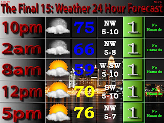
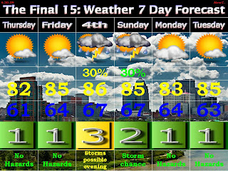
15% chance of severe weather tomorrow...between 4-7pm will be the expected arrival of these storms...damaging winds would be the main threat. Besides this, it will be warm and humid with highs in the middle 80s. More on the severe weather tomorrow, and look at the previous post for the 7-day!
Alex C.
Alex C.
Thursday, July 23, 2009
Thursday, July 23rd, 2009: 9:30pm
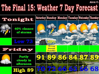
A nice day upcoming for tomorrow...it will be a bit humid but definitely managable for this time of year...
Saturday could yield some strong storms late afternoon and into the evening in approach of a cold front. There could be some severe weather with this so stay tuned...
The rest of the period should have average temperatures for this time of year and will mostly be dry...
Alex C.
Tuesday, July 21, 2009
Tuesday, July 21st, 2009: 10:15pm
Heavy rain possible over the next 18 hours...
Rain will begin falling overnight and will continue through the early afternoon tomorrow. Some heavy rain will be possible tomorrow morning, with rain totals reaching 1.5". Some ponding of water on roadways is possible, along with some minor flooding.
The rest of the 7-day looks pretty good with just slight chances of storms Thursday and Friday. The most substancial rains will be tomorrow and then another system on Saturday.
Alex C.
Monday, July 20, 2009
Friday, July 17, 2009
Friday, July 17th, 2009: 8:30pm
Sunny for the next 5 days...highs in the middle 70s and lows in the mid 50s for the weekend, then highs in the lower-mid 80s in lows in the low 60s through Wednesday. Next chance of storms is Thursday and Friday with highs in the mid-80s in lows in the mid 60s.
Alex C.
Alex C.
Thursday, July 16, 2009
Thursday, July 16th, 2009: 10pm
Wednesday, July 15, 2009
Wednesday, July 15th, 2009: 10am
Tuesday, July 14, 2009
Tuesday, July 14th, 2009: 11:15pm
Expect showers tomorrow morning and some storms possible tomorrow afternoon-Thursday morning. If we can get a little sunshine early afternoon, we could see some isolated severe weather.
The rest of the 7-day features a brilliant weekend and early next week...with low humidities and highs in the 80-85 degree range.
Alex C.
Monday, July 13, 2009
Monday, July 13th, 2009: 10pm
Sunday, July 12, 2009
Sunday, July 12th, 2009: 8:30am
Slight (20-30%) chances of storms exist over the next 6 days. Highs will be in the mid 80s today and tomorrow, in the upper 80s Tuesday, around 90 Wednesday, and in the middle 80s for the rest of the period. Lows will settle in the upper 60s most of the week.
Alex C.
Saturday, July 11, 2009
Saturday, July 11th, 2009: 10am
15% chance of damaging winds >58mph and hail >1" in diameter for our area today. A few severe cluster of storms could impact the area this afternoon, especially the east and south parts of the area. The main threat with these storms will be downbursts and microbursts, which are quick burst of heavy winds. Lightning and heavy rain is also possible...stay tuned....
Alex C.
Saturday, July 11th, 2009: 12:30am
30% chance of severe weather over southern Indiana and northern Kentucky today...main threats damaging winds and large hail...stay tuned...
Rain and storms will be most prevalent on Sunday, with more scattered storms Monday-Wednesday. Skies will clear for late week. Temps will stay around the upper 80s-lower 90s all week. I will be posting on severe weather tomorrow...
Alex C.
Wednesday, July 8, 2009
Wednesday, July 8th, 2009: 10pm
The next two days will be quite hot, with Friday being very humid. Next chance of storms comes Saturday, where there could be a few strong storms around. It will continue to be warm and humid before the storms exit Sunday.
Monday and Tuesday will be warm and dry, with a chance of storms coming in mid week.
Alex C.
Tuesday, July 7, 2009
Tuesday, July 7th, 2009: 9:45pm
Still working on my 7-day graphic, so here is the text version:
- Wednesday: Partly cloudy. High: 85 Low: 67
- Thursday: Mostly Sunny. High: 89 Low: 66
- Friday: Partly Cloudy. High: 93 Low: 72
- Saturday: 40% chance storms. High: 89 Low: 72
- Sunday: 30% chance storms. High: 87 Low: 70
- Monday: Partly cloudy. High: 86 Low: 68
- Tuesday: Mostly sunny. High: 89 Low: 69
Alex C.
Monday, July 6, 2009
Monday, June 6th, 2009: 10:15pm
Warm summer weather will continue through Friday, as temperatures will range from 86-91 in the afternoon and in the 67-71 range in the early morning. It will be dry until the weekend, when a slight storm chance enters into the forecast. Temperatures will remain the same through the weekend and into the first part of early next week.
Alex C.
Alex C.
Saturday, July 4, 2009
Independence Day 2009: 5:30pm
Rain beginning to break up to the west...
Southern Indiana and Louisville: The light rain we have now will continue to get lighter through 7pm, and should be stopped or just as sprinkles by 7:30-8pm. The rain has really broken up into Illinois. We could still have isolated showers/sprinkles through the evening, but nothing widespread. Looking better...
Central Kentucky will see rain continue through a lot of the evening, but could become light enough in some areas to shoot some fireworks around 10, especially the closer you are to Louisville.
Alex C.
Independence Day 2009: 12:45pm
Rain about to begin in our parts of the area...
From the NWS: UPDATED TO DOWNSCALE THUNDERSTORM CHCS (MAINLY NORTH) CHANGED WORDING TO ISOLATED AS WEAKENING MCS MAKES SLOW EWD PROGRESS WITH LEADING EDGE TENDING TO DISSIPATE AS IT ENCOUNTERS DRIER AIR.
However, the storm that they are talking about extends from Corydon to St. Louis right now. However, if it does weaken, we will only see light showers here. From now until about 6pm, however, expect a fairly good threat of light to at times moderate showers. After 6pm, the storms will become more scattered for a while.
The question with the evening is whether storms can develop here. There will likely be severe storms going on in southern Kentucky SOUTH of the warm front, but with no sun and a rain soaked atmosphere, it is questionable whether we will see more widespread showers in the evening. I think there is still a chance of showers, but the threat may be going down. Stay tuned...
Alex C.
Friday, July 3, 2009
Friday, July 3rd, 2009: 9:30pm
There is a good bet for storms sometime tomorrow...here's the rundown...
For the early morning, don't worry too much about a storm chance. The chance will be greatest west of I-65 at noon, and the chance will increase in the afternoon with heating. I don't think these afternoon showers/storms will be that significant, and there may be a gap over parts of the area, especially outhern Indiana, that would allow cookouts to proceed under cloudy skies.
However, the biggest area of storms will come through the area sometime between 7-11pm. The timing will be crucial! Some of these storms could be strong, so stay tuned...I will be posting a lot tomorrow here and on facebook to let you know what to expect for the 4th...
Alex C.
Thursday, July 2, 2009
Thursday, July 2nd, 2009: 10:15pm
Here is your forecast and your 4thcast...
The main action from this storm could end up being in the afternoon, and end before the fireworks, but there could also be two rounds of storms. I will try to have an answer on rain for the fireworks tomorrow...besides that...the weather looks great for the rest of the next week, with near normal temps for July...
Alex C.
Wednesday, July 1, 2009
Wednesday, July 1st, 2009: 9:30pm
The forecast has nice weather except for the 4th of July weekend! The chance of storms looks to come in the afternoon or evening. It is not a guarantee that we will see these storms come through on the 4th depending on the location of the warm front. After the weekend, it will be nice yet again with warm but not humid weather in the 80s.
Here are the details on the 4th of the July with "The Final 15: Weather 4thcast".
Alex C.
Tuesday, June 30, 2009
Tuesday, June 30th, 2009: 10pm
Hopefully you have noticed the new look to my forecasts now...
I have a new 24 hour forecast, and a new look to the the 7 day. Besides the order in which things are placed, the biggest change is with the weather threat numbers. They range from 1-10, with one being a day with "no hazards". As you can see, that text is below the number (beside in the 24 hour forecast).
So, a couple nice days upcoming through Friday. I have a weather threat of 3 for the 4th because of the possibility of storms in the afternoon and evening, which could interrupt activities for the 4th. After this, we will continue to be warm but not very humid into early next week.
Alex C.
Monday, June 29, 2009
Monday, June 29th, 2009: 3:30pm
Here is the forecast...enjoy the great temperatures and low humidities. The only question in this forecast is the storms on the weekend, which could occur during the afternoon and evening on the 4th. It is something that I will be keeping an eye on closely. We will likely either get storms or hot weather again...
Alex C.
Sunday, June 28, 2009
Sunday, June 28th, 2009: 9pm
Thursday, June 25, 2009
Thursday, June 25th, 2009: 4pm
Slight chance of just some summer storms tonight and tomorrow morning, before we begin to clear tomorrow afternoon. We will have more warm and humid weather through Sunday. There are some storms possible on Sunday.
Monday-Thurday's weather will not be as humid, and it will actually be pleasantly warm. It will get more humid towards late next week.
Alex C.
Wednesday, June 24, 2009
Wednesday, June 24th, 2009: 3pm
There is a pretty good bet of showers and storms tomorrow, especially in the afternoon. Some isolated storms could be severe, but the threat of that is very small. If anything, we could see some gusty winds in the storms.
The heat will continue to be on through the weekend before the next storm system arrives on Sunday on storms. After this, we will see a brief cooldown into the middle 80s.
Alex C.
Monday, June 22, 2009
Monday, June 22nd, 2009: 9:30pm
Sunday, June 21, 2009
Fathers Day 2009: 4pm
A fairly simple 7 day here as temperatures remain nearly steady. There will be chances of storms at times throughout the early and late week...
Minor potential for severe weather this Father's Day afternoon and evening. From the SPC: THE THREAT FOR A FEW SEVERE STORMS CAPABLE OF HAIL...LOCALLY DAMAGING WIND GUSTS AND PERHAPS A BRIEF TORNADO OR TWO WILL BE POSSIBLE ACROSS DISCUSSION AREA THIS AFTERNOON INTO EVENING.
This will be nothing major but at least a topic of interest for places north of the river west of I-65...
Alex C.
Friday, June 19, 2009
STORM ALERT: 6/19/09: 10PM
Tornado watch north of Louisville until 3am...
Storms are developoing to our west and northwest and they are severe...
The storms that southern Indiana should be most concerned about currently are the storms in southern Illinois that are south and west of the watch box. These storms are moving east, and that would take them through at least part of southern Indiana. There is also a possibility that there could be storms develop further west in central and southern Missouri, and also slightly further south in Illinois...take a look at the SPC maps...
We have a 5% chance for tornadoes tonight and a 30% chance of damaging hail along and north of the Ohio...
Stay tuned throught the night on this developing situation...
Alex C.
Thursday, June 18, 2009
STORM ALERT: 6/18/09: 9:50PM
Severe threat over for tonight...we'll see what materializes for tomorrow...
Ryan Hoke intercepted 3 small tornadoes and a large wedge tornado while storm chasing yesterday...visit http://ryanweather.blogspot.com to see his incredible video and pictures. In his video, he gets 250 yards away from a 1/2-3/4 mile wide tornado...
Alex C.
Ryan Hoke intercepted 3 small tornadoes and a large wedge tornado while storm chasing yesterday...visit http://ryanweather.blogspot.com to see his incredible video and pictures. In his video, he gets 250 yards away from a 1/2-3/4 mile wide tornado...
Alex C.
STORM ALERT: 6/18/09: 2:45PM
What a crazy storm this morning...many power lines and trees down across the area...some flooding noted as well...
However, we are not done with the severe weather yet. This storm looks small and very far away, but it is none the less severe. The SPC is expected further development to the west and northwest of this storm. The sun is out here, and it is 90 in St. Louis, so there is nothing to stop these storms from incredeasing in coverage and intensity.
We are under a 30% chance of more damaging winds for this evening and tonight. As you also see on this map, part of the midwest is in a 45% range, and that is the weather we will have to watch to see if it comes our way...
Now, tomorrow is another interesting situation...
The 45% chance area is north of I-64 for tomorrow. The timing and positioning of outflow boundaries is more than crucial to this forecast, and the timing and severity of these storms will be influenced by these factors. Still, widespread damaging winds are certainly possible over the area, especially southern Indiana...stay tuned...
Alex C.
Subscribe to:
Posts (Atom)