Tuesday, June 30, 2009

Tuesday, June 30th, 2009: 10pm


Hopefully you have noticed the new look to my forecasts now...
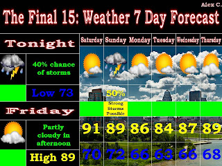
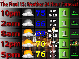
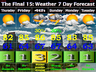
I have a new 24 hour forecast, and a new look to the the 7 day. Besides the order in which things are placed, the biggest change is with the weather threat numbers. They range from 1-10, with one being a day with "no hazards". As you can see, that text is below the number (beside in the 24 hour forecast).
So, a couple nice days upcoming through Friday. I have a weather threat of 3 for the 4th because of the possibility of storms in the afternoon and evening, which could interrupt activities for the 4th. After this, we will continue to be warm but not very humid into early next week.
Alex C.

Monday, June 29, 2009

Monday, June 29th, 2009: 3:30pm


Here is the forecast...enjoy the great temperatures and low humidities. The only question in this forecast is the storms on the weekend, which could occur during the afternoon and evening on the 4th. It is something that I will be keeping an eye on closely. We will likely either get storms or hot weather again...

Alex C.

Sunday, June 28, 2009

Sunday, June 28th, 2009: 9pm


A nice week ahead with low humidities until the weekend. There is the potential for another slight cold front to drop into the area, bringing temperatures to near 80 on Wednesday...

Humidities will increase slightly by the weekend, with a slight chance of storms by Sunday...

Alex C.

Thursday, June 25, 2009

Thursday, June 25th, 2009: 4pm


Slight chance of just some summer storms tonight and tomorrow morning, before we begin to clear tomorrow afternoon. We will have more warm and humid weather through Sunday. There are some storms possible on Sunday.

Monday-Thurday's weather will not be as humid, and it will actually be pleasantly warm. It will get more humid towards late next week.

Alex C.

Wednesday, June 24, 2009

Wednesday, June 24th, 2009: 3pm


There is a pretty good bet of showers and storms tomorrow, especially in the afternoon. Some isolated storms could be severe, but the threat of that is very small. If anything, we could see some gusty winds in the storms.

The heat will continue to be on through the weekend before the next storm system arrives on Sunday on storms. After this, we will see a brief cooldown into the middle 80s.

Alex C.

Monday, June 22, 2009

Monday, June 22nd, 2009: 9:30pm


The 7 day forecast includes many days in the 90s for then next week. There will be no good storm chances in the next 7 days, and the chances on Saturday and Sunday are very slim...

Alex C.

Sunday, June 21, 2009

Fathers Day 2009: 4pm


A fairly simple 7 day here as temperatures remain nearly steady. There will be chances of storms at times throughout the early and late week...

Minor potential for severe weather this Father's Day afternoon and evening. From the SPC: THE THREAT FOR A FEW SEVERE STORMS CAPABLE OF HAIL...LOCALLY DAMAGING WIND GUSTS AND PERHAPS A BRIEF TORNADO OR TWO WILL BE POSSIBLE ACROSS DISCUSSION AREA THIS AFTERNOON INTO EVENING.
This will be nothing major but at least a topic of interest for places north of the river west of I-65...
Alex C.

Friday, June 19, 2009

STORM ALERT: 6/19/09: 10PM


Tornado watch north of Louisville until 3am...

Storms are developoing to our west and northwest and they are severe...


The storms that southern Indiana should be most concerned about currently are the storms in southern Illinois that are south and west of the watch box. These storms are moving east, and that would take them through at least part of southern Indiana. There is also a possibility that there could be storms develop further west in central and southern Missouri, and also slightly further south in Illinois...take a look at the SPC maps...

We have a 5% chance for tornadoes tonight and a 30% chance of damaging hail along and north of the Ohio...

...and a 30% chance for damaging winds. If you look real closely...you will see the damaging surplus line come down to the Clark/Floyd county line, and the 45% from Salem and north/northeast...
Stay tuned throught the night on this developing situation...
Alex C.

Thursday, June 18, 2009

STORM ALERT: 6/18/09: 9:50PM

Severe threat over for tonight...we'll see what materializes for tomorrow...

Ryan Hoke intercepted 3 small tornadoes and a large wedge tornado while storm chasing yesterday...visit http://ryanweather.blogspot.com to see his incredible video and pictures. In his video, he gets 250 yards away from a 1/2-3/4 mile wide tornado...

Alex C.

STORM ALERT: 6/18/09: 2:45PM

What a crazy storm this morning...many power lines and trees down across the area...some flooding noted as well...

However, we are not done with the severe weather yet. This storm looks small and very far away, but it is none the less severe. The SPC is expected further development to the west and northwest of this storm. The sun is out here, and it is 90 in St. Louis, so there is nothing to stop these storms from incredeasing in coverage and intensity.

We are under a 30% chance of more damaging winds for this evening and tonight. As you also see on this map, part of the midwest is in a 45% range, and that is the weather we will have to watch to see if it comes our way...

Now, tomorrow is another interesting situation...

The 45% chance area is north of I-64 for tomorrow. The timing and positioning of outflow boundaries is more than crucial to this forecast, and the timing and severity of these storms will be influenced by these factors. Still, widespread damaging winds are certainly possible over the area, especially southern Indiana...stay tuned...

Alex C.

STORM ALERT: 6/18/09: 9:30AM


Severe storms complex will move through the area, mainly impacting places along and west of I-65 with severe weather. Damaging winds are the main threats...

Storms may redevelop this afternoon, but these will likely begin along or south of the Ohio River.

Not much time to post now...but moderate (45%) risk of severe weather along and north of I-64...more later...

Alex C.

Wednesday, June 17, 2009

Wednesday, June 17th, 2009: 9:15pm


Here is the forecast for the next 7 days...highlighted by the many chances of severe weather and extreme heat...

The severe risk has ended for tonight except for central and southern Kentucky, and even that activity is waning.

Severe Opportunity #1: Thursday late morning-afternoon:


The SPC has Louisville and points southeast in a 30% chance of severe weather...and the rest of the area in a 15% chance of severe. This will not be anything widespread, but some severe weather is possible. Theses storms will intensify around noon, and it will depend on where they begin and how strong they get to see who will get the most severe weather. If southern Indiana does see any activity, the main severe threat will be large hail.

If we do not see storms, it will indeed be very warm and humid. Highs could reach 90 with no rain, and dewpoints in the 70s will bring heat indexes close to 100! Stay cool...

This will continue into Friday, with highs in the low 90s and heat indices near 100 again.

Severe Opportunity #2: Friday evening

Most of the area is in a 30% chance of severe weather for Friday. With very warm temps and dewpoints in place, along with many other aspects of severe weather in place, we could see a violent outbreak of severe storms. This from the SPC:
STRONG DEEP LAYER SHEAR ALONG/AHEAD OF ADVANCING COLD FRONT STRONGLY FAVORS ORGANIZED SEVERE THUNDERSTORMS ACROSS PORTIONS OF THE MID MS VALLEY...EWD ACROSS THE ENTIRE OH VALLEY REGION BY LATE EVENING.ORGANIZED SEVERE THUNDERSTORMS SHOULD EASILY DEVELOP BY 18Z THEN SPREAD RAPIDLY ESEWD WITHIN MEAN FLOW APPROACHING 50KT. DAMAGING WINDS APPEAR LIKELY IF THIS SCENARIO UNFOLDS WITH THE POTENTIAL FOR SIGNIFICANT SEVERE...POSSIBLY A DERECHO.

Remember this is not guaranteed...but there is the potential. For those who do not know what a derecho is...here's a picture and a brief description from Wikipedia:


A derecho (from Spanish: "derecho" meaning "straight") is a widespread and long-lived, violent convectively induced straight-line windstorm that is associated with a fast-moving band of severe thunderstorms in the form of a squall line usually taking the form of a bow echo. Winds in a derecho can be enhanced by downburst clusters embedded inside the storm. These straight-line winds can exceed 100 mi/hr (160 km/hr). Tornadoes sometimes form within derecho events, although such events are often difficult to confirm due to the additional damage caused by straight-line winds in the immediate area.

So, a lot to watch for in the next couple of days...stay tuned...I will post as much as possible or needed...

Alex C.

Tuesday, June 16, 2009

Tuesday, June 16th, 2009: 12:30pm

Severe thunderstorm watch is in effect until 6pm for southern Indiana and northcentral Kentucky along and west of I-65. A line of severe storms is moving into western Kentucky at this time. The worst of the weather as it is now will stay south of the river, but if the storms on the north part of the line intensify, severe storms will become more likely over southern Indiana...stay tuned...

Alex C.

Tuesday, June 16th, 2009: 10am

Severe weather possible this afternoon and evening...

I am forecasting the potential of severe thunderstorms this afternoon. All of the proper severe weather elements are in place, except for the fact that there will not be much clearing this afternoon. Assuming this is overcome, WNW winds aloft combined with ESE winds at the surface will cause rotating storms this afternoon. This will bring the potential for damaging winds, large hail, and isolated tornadoes.

The SPC maps are not at all congruent with my thinking, so I will not post them at this time. There is a slight risk of severe thunderstorms for us, however. Marc Weinberg shared this morning that he thinks a moderate risk should be placed from Shepherdsville, KY, to Salem, IN, for the threat of tornadoes...stay tuned...

Alex C.

Monday, June 15, 2009

Monday, June 15th, 2009: 5pm


Very interesting week of weather upcoming, and my blog will cover every moment of it...

We will start out with a chance of storms tonight, but that will fade away into a warm, humid, morning tomorrow.

There will be 3 major weather headlines for the week...here they all are, in order...
  • Tuesday afternoon and Tuesday night: A stationary front will be lifting northward and will be the focusing mechanism for storms in this time period. The following is the SPC map for tomorrow, with a 30% chance of severe weather southwest of Louisville.

  • They say that a moderate risk may be put into place, but for now it is just a slight risk. The highest concentration severe storms will be north of where the stationary front sets up. The main threats with these storms will be damaging winds, but isolated tornadoes and large hail are possible close to the stationary front, which will most likely be in western/southern Kentucky.
  • Thursday-Friday: We will see the hottest weather of the summer thus far. Highs will be in the lower-mid 90s, and humidity will be very high, iwth dewpoints in the 70s possible. Stay tuned and take your normal precautions for being in hot weather.
  • Friday night/Saturday: The SPC indicates a 30% chance of severe weather for Friday night over southern Indiana. With hot temperatures and high humidity in place, severe storms are certainly possible (see map below and stay tuned).

Alex C.

Friday, June 12, 2009

Friday, June 12th, 2009: 10pm


Here is the forecast for the next 7 days...

The best chance for strong storms will be Sunday and again on Tuesday. These storms will most likely not be severe, and will end by Wednesday, when we will begin a warming trend.

Alex C.

Thursday, June 11, 2009

Thursday, June 11th, 2009: 7pm


Here is your forecast...big news is tornado watch currently in affect until 1 am for southern Indiana and northcentral Kentucky.

Storms are severe now south of the river, with tornado warnings for Leitchfield. Those storms will stay south of Louisville. A secondary severe threat may be coming out of central Indiana...stay tuned...

Alex C.

Sunday, June 7, 2009

Sunday, June 7th, 2009: 8:30am

Here is your forecast for the area for the week. I'm off to summer camp and will not be posting again until Wednesday night...


Meanwhile, we will have a few very warm days. We will see a slight chance of storms Monday afternoon, with more widespread storms late Monday night. Those storms could be strong, with a slight risk of severe storms west of I-65. Tuesday could have some more numerous storms in the afternoon. After this system moves through, we will see very pleasant weather.


My weather friend Ryan Hoke is storm chasing in the Plains through the 19th. To see stories of his adventures, pictures, and video, you can go to one of these sites:

Alex C.

Friday, June 5, 2009

Friday, June 5th, 2009: 9:30pm


Here's the new forecast for the area...

A very cool night tonight will lead to a few warm days in a row. Next storm system will come in with isolated storms on Monday and more widespread storms Tuesday, before another slight cooldown...

Alex C.

Thursday, June 4, 2009

Thursday, June 4th, 2009: 4pm


For information on my lightning video...see the previous post (below)...

So much for my forecast for today...I think all meteorologists will agree that we completely blew the forecast for today. I certainly thought that the clouds, at least the low clouds, would clear sooner, and we would get around 70. However, it is 4pm and my weather station says 59!!! On June 4th, really?

I think that the clouds will stick around long enough to keep the temps from falling to the low 50s tonight. What happens tonight is actually indicative of the temperatures for the next few days. If my forecast for tonight is correct, the temps will get to around 80 on Friday and into the upper 80s for Saturday. Also, I forecast that we will see lower 90s for Sunday and Monday. However, if temps go into the lower 50s tonight, temps over the course of the next few days wil be about 3-5 degrees cooler than I have forecasted.

If my forecast is right, hot weather will be the order for Sunday, and very hot and humid weather will be in store Monday, with just isolated storms. Another humid day will be in the works for Tuesday as our next storm system comes in. I think that with the moisture at least, I should at least mention the potential for strong storms Tuesday. The storm system will clear by late Wednesday...

Alex C.

Wednesday, June 3, 2009

Wednesday, June 3rd, 2009: 9pm

I am making my video and pictures of the incredibly close lightning strike from Tuesday night available to the public through Saturday at 8pm. Please email your request of the video and pictures to hookedonweather@aol.com, and I will email them to you on Saturday night. To view the photos...see the previous post. The video was not uploaded to the blog, so that is only available upon request. This media can then be reproduced upon my consent...just so that I get the credit for the pictures and video...thank you...
The forecast has storms ending to our south this evening. Tomorrow will be a very cool, dull day in the morning, but we will see things turn for the better by Friday. If this storm clears quickly tomorrow, we will see lows in the 50s tomorrow night...
Next storm system brings a chance of storms Monday, with isolated storms on Sunday and Tuesday. We will have a brief cooldown mid next week before a warm up for the latter part of the week...
Alex C.

Tuesday, June 2, 2009

Tuesday, June 2nd, 2009: 10pm


Here is your 7-day forecast...discussion below...

Storms raced in this evening, some severe, and were moving further ahead of the front than expected. Expect to see more storms tomorrow...and end by early Thursday morning...

Some forecasts are showing that the rain will stick around through Thursday, which would hold highs in the upper 60's. I think that these storms will help force the front through by Thursday morning, and we could see some clearing in the afternoon...

A quick weekend warmup will preclude another storm system, bringing summerlike storms to the area early next week! Note: It will not be a wash out, just some common 15-30 minute summer storms. Most widespread storms will be seen on Monday...

Tonight I got some spectacular video of lightning. I cannot upload the video because of dial-down internet, but here are some still from it.


You cannot tell from these pictures, but the lightning was so close that the thunder and lightning were indistinguishable in time. Next time I'm on hispeed internet, I'll upload the video...

Alex C.


Monday, June 1, 2009

Monday, June 1st, 2009: 9pm


Get ready for a hot and humid day tomorrow...temps will be nearing 90 and humidity will be much higher than today.

A storm system will impact the area Wednesday afternoon and evening, giving a decent chance of storms. Severe storms are not expected, and if any would occur, they would be very isolated (1 or 2). These storms will end Thursday morning.

It will be nice for the end of the week until another storm system impacts the area at the end of the weekend and early next week...

Alex C.